

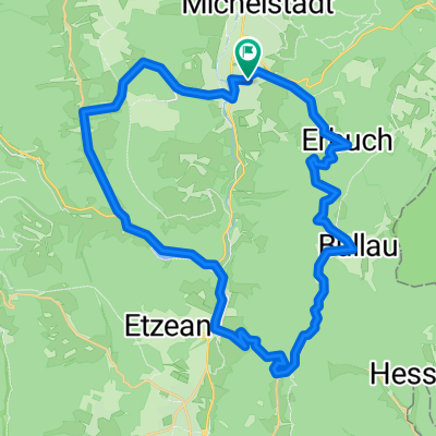
Strecke: Rund im Odenwald 2004 U23
A cycling route starting in Erbach im Odenwald, Hesse, Germany.
Overview
About this route
The more you write here, the more helpful it is for other users.
- Route description.
- Why do you like this route?
- Why would you recommend it?
- What are the highlights?
- etc. FB_Addon_TelNo{ height:15px !important; white-space: nowrap !important; background-color: #0ff0ff;} FB_Addon_TelNo{ height:15px !important; white-space: nowrap !important; background-color: #0ff0ff;}
- -:--
- Duration
- 84.7 km
- Distance
- 1,190 m
- Ascent
- 905 m
- Descent
- ---
- Avg. speed
- ---
- Max. altitude
Route quality
Waytypes & surfaces along the route
Waytypes
Road
22 km
(26 %)
Track
8.5 km
(10 %)
Surfaces
Paved
50.8 km
(60 %)
Unpaved
8.5 km
(10 %)
Asphalt
44.9 km
(53 %)
Gravel
6.8 km
(8 %)
Continue with Bikemap
Use, edit, or download this cycling route
You would like to ride Strecke: Rund im Odenwald 2004 U23 or customize it for your own trip? Here is what you can do with this Bikemap route:
Free features
- Save this route as favorite or in collections
- Copy & plan your own version of this route
- Split it into stages to create a multi-day tour
- Sync your route with Garmin or Wahoo
Premium features
Free trial for 3 days, or one-time payment. More about Bikemap Premium.
- Navigate this route on iOS & Android
- Export a GPX / KML file of this route
- Create your custom printout (try it for free)
- Download this route for offline navigation
Discover more Premium features.
Get Bikemap PremiumFrom our community
Other popular routes starting in Erbach im Odenwald
 2. Tour Odenwald Klinge
- Distance
- 104.8 km
- Ascent
- 1,125 m
- Descent
- 1,125 m
- Location
- Erbach im Odenwald, Hesse, Germany
 Raubacher Runde
- Distance
- 60.4 km
- Ascent
- 970 m
- Descent
- 970 m
- Location
- Erbach im Odenwald, Hesse, Germany
 Westliche Rundtour
- Distance
- 44.3 km
- Ascent
- 602 m
- Descent
- 604 m
- Location
- Erbach im Odenwald, Hesse, Germany
 RSG - Rund im Odenwald 2008
- Distance
- 113 km
- Ascent
- 2,007 m
- Descent
- 1,866 m
- Location
- Erbach im Odenwald, Hesse, Germany
 Von Hüttenthal nach Keilbach
- Distance
- 24 km
- Ascent
- 547 m
- Descent
- 588 m
- Location
- Erbach im Odenwald, Hesse, Germany
 09.08
09.08- Distance
- 30 km
- Ascent
- 490 m
- Descent
- 488 m
- Location
- Erbach im Odenwald, Hesse, Germany
 kleine hügelrunde um erbach
- Distance
- 37.2 km
- Ascent
- 874 m
- Descent
- 842 m
- Location
- Erbach im Odenwald, Hesse, Germany
 Odenwald 1
- Distance
- 41.8 km
- Ascent
- 673 m
- Descent
- 648 m
- Location
- Erbach im Odenwald, Hesse, Germany
Open it in the app