
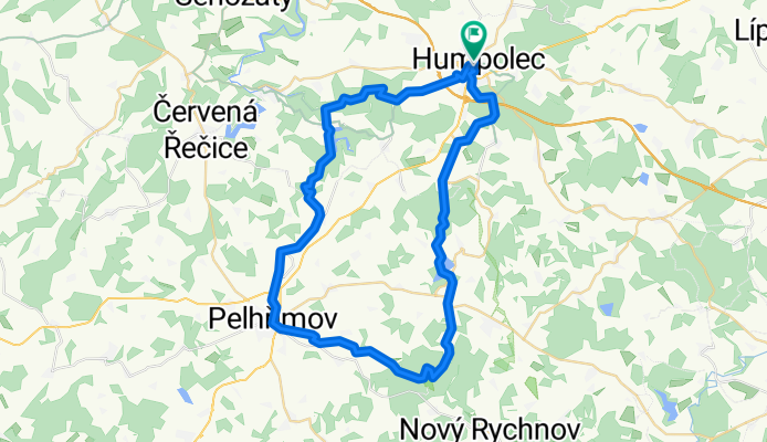
Humpolec-pod Křemešníkem-Pelhřimov-Sedlice-U Pihávka-Humpolec (Corrida)
A cycling route starting in Humpolec, Kraj Vysočina, Czechia.
Overview
About this route
The entire route can be followed according to the tourist signs.
- -:--
- Duration
- 51.6 km
- Distance
- 697 m
- Ascent
- 699 m
- Descent
- ---
- Avg. speed
- ---
- Max. altitude

Route quality
Waytypes & surfaces along the route
Waytypes
Track
19.6 km
(38 %)
Quiet road
9.8 km
(19 %)
Surfaces
Paved
12.9 km
(25 %)
Unpaved
17 km
(33 %)
Ground
9.8 km
(19 %)
Asphalt
9.3 km
(18 %)
Route highlights
Points of interest along the route
Point of interest after 11.5 km
železná lávka
Point of interest after 18.4 km
nejvyšší vrchol Pelhřimovska - Křemešník (765m n.m.)
Point of interest after 38 km
Dřevěný most
Point of interest after 38.9 km
Šperná skála - vyhlídka
Point of interest after 41.1 km
U Pihávka
Point of interest after 51.6 km
letní teráska Corrida
Continue with Bikemap
Use, edit, or download this cycling route
You would like to ride Humpolec-pod Křemešníkem-Pelhřimov-Sedlice-U Pihávka-Humpolec (Corrida) or customize it for your own trip? Here is what you can do with this Bikemap route:
Free features
- Save this route as favorite or in collections
- Copy & plan your own version of this route
- Sync your route with Garmin or Wahoo
Premium features
Free trial for 3 days, or one-time payment. More about Bikemap Premium.
- Navigate this route on iOS & Android
- Export a GPX / KML file of this route
- Create your custom printout (try it for free)
- Download this route for offline navigation
Discover more Premium features.
Get Bikemap PremiumFrom our community
Other popular routes starting in Humpolec
 Humpolecká 50
- Distance
- 25.9 km
- Ascent
- 474 m
- Descent
- 474 m
- Location
- Humpolec, Kraj Vysočina, Czechia
 JIříce Senožaty Křelovice Želiv Sedlice Hněvkovice Jiřice
- Distance
- 32.7 km
- Ascent
- 460 m
- Descent
- 464 m
- Location
- Humpolec, Kraj Vysočina, Czechia
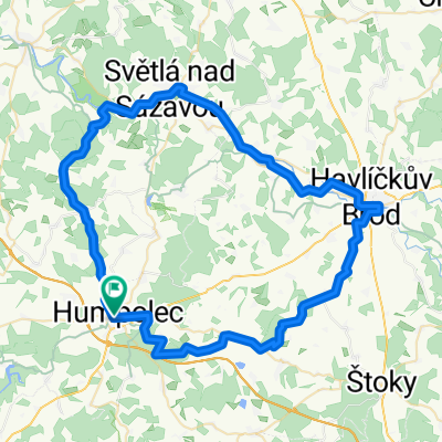 Humpolec-Rohule-Světlá nad Sázavou-Havlíčkův Brod-Lípa-Herálec-Plačkov-Humpolec
- Distance
- 69.1 km
- Ascent
- 607 m
- Descent
- 605 m
- Location
- Humpolec, Kraj Vysočina, Czechia
 Humpolec-pod Křemešníkem-Pelhřimov-Sedlice-U Pihávka-Humpolec (Corrida)
- Distance
- 51.6 km
- Ascent
- 697 m
- Descent
- 699 m
- Location
- Humpolec, Kraj Vysočina, Czechia
 Jiřické kopečky 2 aneb Pain in the ass
- Distance
- 33.7 km
- Ascent
- 475 m
- Descent
- 475 m
- Location
- Humpolec, Kraj Vysočina, Czechia
 29. maj
- Distance
- 73 km
- Ascent
- 1,310 m
- Descent
- 1,473 m
- Location
- Humpolec, Kraj Vysočina, Czechia
 Humpolec - Proseč - Stará Huť - Kaliště - Lohenice - Speřice - Kopaniny - Jiřice - Hněvkovice - Humpolec
- Distance
- 26.5 km
- Ascent
- 313 m
- Descent
- 305 m
- Location
- Humpolec, Kraj Vysočina, Czechia
 Humpolec - Želiv a zpět
- Distance
- 30.1 km
- Ascent
- 476 m
- Descent
- 476 m
- Location
- Humpolec, Kraj Vysočina, Czechia
Open it in the app