

Chawish Nawattranakul
- Location
- United States
- Time on Bikemap
- Member since 12/18/2015
My routes
Planned and recorded rides


Collections and multi-stage tours
 Collection
Discover
My most popular routes

ปั่นเข้าหลวงพระบาง
Cycling route in Luang Prabang, Luang Prabang Province, Laos
- 9.3 km
- Distance
- 112 m
- Ascent
- 95 m
- Descent

น้ำตกตาดแซ่
Cycling route in Luang Prabang, Luang Prabang Province, Laos
- 40.5 km
- Distance
- 409 m
- Ascent
- 409 m
- Descent

Huaikon Pakbang
Cycling route in Chaloem Phra Kiat, Nan, Thailand
จากห้วยโกร๋นปั่นมา40กว่าเหลืออีก22กม.ถึงปากแบ่ง ลงเขาเร็วเบรคนานจนขอบล้อร้อนยางล้อหลังแตก กลัวมืดโบกรถผู้รับเหมาชาวลาวพี่เสริฐใจดีรับขึ้นมาส่งถึงที่พัก
- 57.6 km
- Distance
- 1,011 m
- Ascent
- 1,124 m
- Descent


Long ride from Ho Chi Minh City to Vung Tau City
Cycling route in Quận Ba, Ho Chi Minh City, Vietnam
- 99.5 km
- Distance
- 102 m
- Ascent
- 102 m
- Descent
More routes from United States
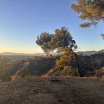 evening ride 10/16
- Distance
- 17.1 km
- Ascent
- 301 m
- Descent
- 302 m
- Location
- Silver Lake, California, United States
 Heart of Ohio Trail, Centerburg to Heart of Ohio Trail, Centerburg
- Distance
- 62.9 km
- Ascent
- 175 m
- Descent
- 180 m
- Location
- Centerburg, Ohio, United States
 Cottage Ave, Mount Vernon to New Rochelle
- Distance
- 12.5 km
- Ascent
- 82 m
- Descent
- 121 m
- Location
- Mount Vernon, New York, United States
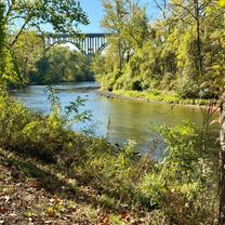 Towpath Trail, Lock 39 Trailhead
- Distance
- 30.9 km
- Ascent
- 53 m
- Descent
- 55 m
- Location
- Valley View, Ohio, United States
 48.062, -122.592 to 48.061, -122.595
- Distance
- 0.6 km
- Ascent
- 25 m
- Descent
- 35 m
- Location
- Freeland, Washington, United States
 Black Dog Rd, Burnsville to Black Dog Rd, Burnsville
- Distance
- 11.6 km
- Ascent
- 7 m
- Descent
- 7 m
- Location
- Burnsville, Minnesota, United States