
STKP
STKP Cycling Collection
A collection of 20 cycling routes.
Overview
About this collection
A mixed-terrain set of rides under the STKP banner. Expect a blend of quiet roads and long stretches of forest/farm tracks, with bits of cycleway and the odd busy connector. Surfaces vary a lot: smooth asphalt, plenty of gravel and other unpaved sections, plus occasional cobbles and short wooden bridges.
There’s a lot of climbing across the collection, so gears and good brakes matter. A gravel or MTB setup with sturdy, wider tires is ideal; tough touring bikes can work if you’re comfortable on rough stuff.
Pick and mix segments to suit your time and mood—short spins or bigger days are both on the table. Download offline maps, carry basic tools, and be ready for conditions to shift (gravel can turn muddy fast). Watch for living streets and pedestrian areas where you’ll need to roll slow and share space. Enjoy the variety and the quieter back roads that tie it all together.
- 20
- Routes
- -:--
- Duration
- 435.6 km
- Distance
- ---
- Avg. speed
- 18,960 m
- Ascent
- 18,512 m
- Descent
STKP Cycling Collection
Routes in this collection
All 20 routes in this collection can be opened on the map or in the Bikemap App for more details, where you can adjust them in the route planner, or download them as GPX or KML file. Use them as a template for planning your own rides, or let Bikemap navigate you along them directly.

STKP Ruška koča – Ribniška koča
Cycling route in Ruše, Ruše Municipality, Slovenia
- 21.7 km
- Distance
- 765 m
- Ascent
- 780 m
- Descent

STKP Pekre to Maribor
Cycling route in Pekre, Maribor City Municipality, Slovenia
- 17.7 km
- Distance
- 279 m
- Ascent
- 1,076 m
- Descent

STKP: Sv. Trojica v Slov. Goricah – Maribor
Cycling route in Sv. Trojica v Slov. Goricah, Sveta Trojica v Slovenskih Goricah, Slovenia
- 31.9 km
- Distance
- 789 m
- Ascent
- 787 m
- Descent

STKP: Sv. Trojica v Slov. Goricah – Juršinci
Cycling route in Sv. Trojica v Slov. Goricah, Sveta Trojica v Slovenskih Goricah, Slovenia
- 36.7 km
- Distance
- 663 m
- Ascent
- 661 m
- Descent
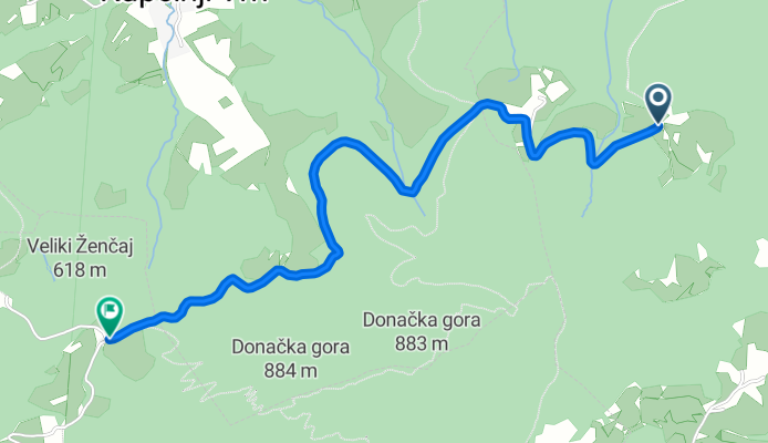
STKP: Rogatec to Žetale
Cycling route in Rogatec, Rogatec, Slovenia
- 2.7 km
- Distance
- 205 m
- Ascent
- 147 m
- Descent

STKP: Šentjur pri Celju – Poljčane (Resevna–Uršula–Boč)
Cycling route in Šentjur pri Celju, Šentjur Municipality, Slovenia
- 43.1 km
- Distance
- 1,390 m
- Ascent
- 1,794 m
- Descent

STKP Ruška koča – Ribniška koča
Cycling route in Lovrenc na Pohorju, Lovrenc na Pohorju, Slovenia
- 24 km
- Distance
- 1,142 m
- Ascent
- 903 m
- Descent

STKP: Ribniška koča – Dom na Košenjaku (Ribnica na Pohorju → Legen)
Cycling route in Ribnica na Pohorju, Ribnica na Pohorju, Slovenia
- 8.8 km
- Distance
- 243 m
- Ascent
- 489 m
- Descent

STKP Dom na Košenjaku – Poštarski dom pod Plešivcem
Cycling route in Dravograd, Dravograd, Slovenia
- 27.6 km
- Distance
- 1,356 m
- Ascent
- 1,646 m
- Descent

STKP Dom na Košenjaku – Poštarski dom pod Plešivcem
Cycling route in Dravograd, Dravograd, Slovenia
- 14.5 km
- Distance
- 1,086 m
- Ascent
- 264 m
- Descent

STKP: Kotlje to Mežica
Cycling route in Kotlje, Občina Ravne na Koroškem, Slovenia
- 7.8 km
- Distance
- 476 m
- Ascent
- 589 m
- Descent
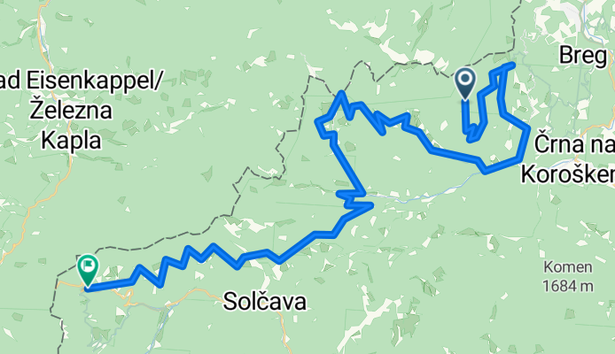
STKP: Solčava – Črna na Koroškem
Cycling route in Solčava, Solčava Municipality, Slovenia
- 52.6 km
- Distance
- 3,264 m
- Ascent
- 3,783 m
- Descent