Feuerwehr Bewegt 2019
Feuerwehr-Bewegt 2019 Rot
A cycling route starting in Schüttorf, Lower Saxony, Germany.
Overview
About this route
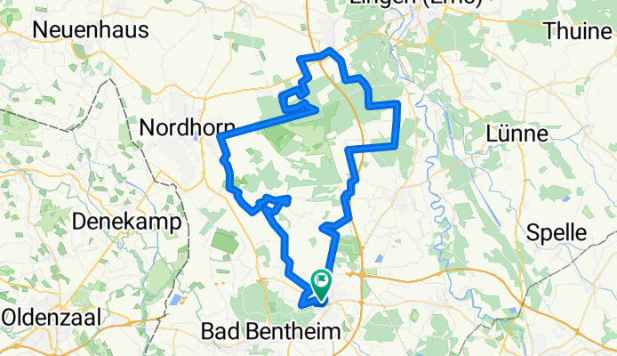
Feuerwehr_Bewegt_2019 Route 'Red' (Manfred):
Saturday 06.07.2019 approx. 73 km
Through the Vechte valley, via Elbergen to Lohne. There is a supply point here. From there around the Klausheide airfield, along the Ems Vechte Canal, here we leave the BW Air/Ground shooting range Nordhorn Range to the left, heading towards Brandlecht and via Engden Neerlage back to Schüttorf.
- -:--
- Duration
- 73 km
- Distance
- 76 m
- Ascent
- 78 m
- Descent
- ---
- Avg. speed
- ---
- Max. altitude
Part of
5 stages
Route quality
Waytypes & surfaces along the route
Waytypes
Quiet road
55.5 km
(76 %)
Track
7.3 km
(10 %)
Surfaces
Paved
43.1 km
(59 %)
Unpaved
8.8 km
(12 %)
Asphalt
27 km
(37 %)
Paved (undefined)
13.9 km
(19 %)
Continue with Bikemap
Use, edit, or download this cycling route
You would like to ride Feuerwehr-Bewegt 2019 Rot or customize it for your own trip? Here is what you can do with this Bikemap route:
Free features
- Save this route as favorite or in collections
- Copy & plan your own version of this route
- Sync your route with Garmin or Wahoo
Premium features
Free trial for 3 days, or one-time payment. More about Bikemap Premium.
- Navigate this route on iOS & Android
- Export a GPX / KML file of this route
- Create your custom printout (try it for free)
- Download this route for offline navigation
Discover more Premium features.
Get Bikemap PremiumFrom our community
Other popular routes starting in Schüttorf
- Grafschafter Fietsentour (GFT) Nr. 21
- Distance
- 37.3 km
- Ascent
- 77 m
- Descent
- 80 m
- Location
- Schüttorf, Lower Saxony, Germany
- Schüttorf -> Schümers Damm -> Alter Postdamm
- Distance
- 27.2 km
- Ascent
- 42 m
- Descent
- 42 m
- Location
- Schüttorf, Lower Saxony, Germany
- Eine Trainingsrunde
- Distance
- 31 km
- Ascent
- 84 m
- Descent
- 84 m
- Location
- Schüttorf, Lower Saxony, Germany
- Sommerabendtour ab Schüttorf rund um Bad Bentheim
- Distance
- 25.1 km
- Ascent
- 77 m
- Descent
- 74 m
- Location
- Schüttorf, Lower Saxony, Germany
- Antekoje-Schüttorf
- Distance
- 32 km
- Ascent
- 32 m
- Descent
- 30 m
- Location
- Schüttorf, Lower Saxony, Germany
- Feuerwehr_Bewegt_Orange
- Distance
- 62.6 km
- Ascent
- 162 m
- Descent
- 160 m
- Location
- Schüttorf, Lower Saxony, Germany
- Schuttorf 16-06-18
- Distance
- 32.3 km
- Ascent
- 82 m
- Descent
- 83 m
- Location
- Schüttorf, Lower Saxony, Germany
- Else am See
- Distance
- 17.1 km
- Ascent
- 68 m
- Descent
- 64 m
- Location
- Schüttorf, Lower Saxony, Germany
Open it in the app