

von Brunnen zu Brunnen nach Erbach
A cycling route starting in Höchst im Odenwald, Hesse, Germany.
Overview
About this route
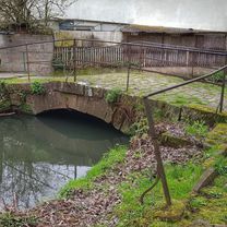
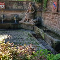
Today a few degrees warmer than yesterday, so just a relaxed ride on the Mümlingtal bike path to Erbach. On the way, I wanted to look for the village fountain in Stockheim. I found it right away, right next to the Stockheim mill. The fountain and mill are protected monuments. Then on to the Lustgarten in Erbach and an easy ride back to Höchst. #noebike
- -:--
- Duration
- 43.2 km
- Distance
- 201 m
- Ascent
- 199 m
- Descent
- ---
- Avg. speed
- ---
- Max. altitude

Route photos


Route quality
Waytypes & surfaces along the route
Waytypes
Quiet road
18.6 km
(43 %)
Track
13.4 km
(31 %)
Surfaces
Paved
28.9 km
(67 %)
Unpaved
4.3 km
(10 %)
Asphalt
28.5 km
(66 %)
Gravel
2.2 km
(5 %)
Continue with Bikemap
Use, edit, or download this cycling route
You would like to ride von Brunnen zu Brunnen nach Erbach or customize it for your own trip? Here is what you can do with this Bikemap route:
Free features
- Save this route as favorite or in collections
- Copy & plan your own version of this route
- Sync your route with Garmin or Wahoo
Premium features
Free trial for 3 days, or one-time payment. More about Bikemap Premium.
- Navigate this route on iOS & Android
- Export a GPX / KML file of this route
- Create your custom printout (try it for free)
- Download this route for offline navigation
Discover more Premium features.
Get Bikemap PremiumFrom our community
Other popular routes starting in Höchst im Odenwald
 durch den Mühlgrund
- Distance
- 42.9 km
- Ascent
- 411 m
- Descent
- 408 m
- Location
- Höchst im Odenwald, Hesse, Germany
 Rimhorn-Lützelbach-Hainstadt Runde
- Distance
- 30.4 km
- Ascent
- 617 m
- Descent
- 620 m
- Location
- Höchst im Odenwald, Hesse, Germany
 über die Hohe Straße
- Distance
- 25.3 km
- Ascent
- 377 m
- Descent
- 373 m
- Location
- Höchst im Odenwald, Hesse, Germany
 Wald-Amorbach Runde
- Distance
- 21.8 km
- Ascent
- 579 m
- Descent
- 580 m
- Location
- Höchst im Odenwald, Hesse, Germany
 Zum Brauereihoffest Ederbräu
- Distance
- 39 km
- Ascent
- 480 m
- Descent
- 479 m
- Location
- Höchst im Odenwald, Hesse, Germany
 zum Schloß Fürstenau
- Distance
- 34.7 km
- Ascent
- 246 m
- Descent
- 244 m
- Location
- Höchst im Odenwald, Hesse, Germany
 von Brunnen zu Brunnen nach Erbach
- Distance
- 43.2 km
- Ascent
- 201 m
- Descent
- 199 m
- Location
- Höchst im Odenwald, Hesse, Germany
 zum Obernburger Waldhaus
- Distance
- 35.6 km
- Ascent
- 327 m
- Descent
- 324 m
- Location
- Höchst im Odenwald, Hesse, Germany
Open it in the app