
zum Biergarten nach Umscht
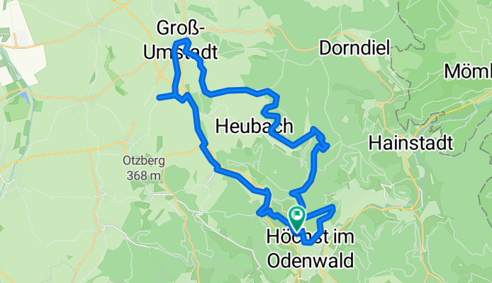
A cycling route starting in Höchst im Odenwald, Hesse, Germany.
Overview
About this route
Today perfect beer garden weather. So hop on the bike and off we go. To warm up, first up to Schorschberg. Then down into the Kellergrund. Passing the Heubach sports field then climbing up to Kehrmich. Here nice views towards Umstadt and Otzberg. Then down to the beer garden under old chestnut trees. After food and drink, up through Wiebelsbach to the Rondell and then home. #noebike
- -:--
- Duration
- 30.8 km
- Distance
- 470 m
- Ascent
- 465 m
- Descent
- ---
- Avg. speed
- ---
- Max. altitude

Route photos


Route quality
Waytypes & surfaces along the route
Waytypes
Track
19.1 km
(62 %)
Quiet road
4.9 km
(16 %)
Surfaces
Paved
10.2 km
(33 %)
Unpaved
14.8 km
(48 %)
Asphalt
8.6 km
(28 %)
Gravel
7.4 km
(24 %)
Continue with Bikemap
Use, edit, or download this cycling route
You would like to ride zum Biergarten nach Umscht or customize it for your own trip? Here is what you can do with this Bikemap route:
Free features
- Save this route as favorite or in collections
- Copy & plan your own version of this route
- Sync your route with Garmin or Wahoo
Premium features
Free trial for 3 days, or one-time payment. More about Bikemap Premium.
- Navigate this route on iOS & Android
- Export a GPX / KML file of this route
- Create your custom printout (try it for free)
- Download this route for offline navigation
Discover more Premium features.
Get Bikemap PremiumFrom our community
Other popular routes starting in Höchst im Odenwald
 durch den Mühlgrund
- Distance
- 42.9 km
- Ascent
- 411 m
- Descent
- 408 m
- Location
- Höchst im Odenwald, Hesse, Germany
 Wald-Amorbach Runde
- Distance
- 21.8 km
- Ascent
- 579 m
- Descent
- 580 m
- Location
- Höchst im Odenwald, Hesse, Germany
 Frankfurter Straße-Binselberg-Wendelinuskapelle-Umstadt
- Distance
- 35.7 km
- Ascent
- 479 m
- Descent
- 477 m
- Location
- Höchst im Odenwald, Hesse, Germany
 Zur Konfirmanden Buche und in den Kellergrund
- Distance
- 25.4 km
- Ascent
- 789 m
- Descent
- 785 m
- Location
- Höchst im Odenwald, Hesse, Germany
 über die Hohe Straße
- Distance
- 25.3 km
- Ascent
- 377 m
- Descent
- 373 m
- Location
- Höchst im Odenwald, Hesse, Germany
 Matschetreten Rund um Höchst im #Odenwald
- Distance
- 32.7 km
- Ascent
- 716 m
- Descent
- 719 m
- Location
- Höchst im Odenwald, Hesse, Germany
 zum Obernburger Waldhaus
- Distance
- 35.6 km
- Ascent
- 327 m
- Descent
- 324 m
- Location
- Höchst im Odenwald, Hesse, Germany
 Rimhorn-Lützelbach-Hainstadt Runde
- Distance
- 30.4 km
- Ascent
- 617 m
- Descent
- 620 m
- Location
- Höchst im Odenwald, Hesse, Germany
Open it in the app