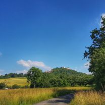
- 31.2 km
- 441 m
- 437 m
- Höchst im Odenwald, Hesse, Germany
zum Historischen Altstadtfest in Breuberg-Neustadt
A cycling route starting in Höchst im Odenwald, Hesse, Germany.
Overview
About this route
Today we are going to the old town festival in Neustadt. But first, you have to earn a beer. At the festival, we drank free beer from a young craft brewer (for a voluntary donation). Sooooooo delicious. #noebike
- -:--
- Duration
- 21.9 km
- Distance
- 341 m
- Ascent
- 339 m
- Descent
- ---
- Avg. speed
- ---
- Max. altitude
created this 6 years ago
Route photos
Route quality
Waytypes & surfaces along the route
Waytypes
Track
12.7 km
(58 %)
Road
4.6 km
(21 %)
Surfaces
Paved
3.3 km
(15 %)
Unpaved
11.2 km
(51 %)
Unpaved (undefined)
8.3 km
(38 %)
Asphalt
3.3 km
(15 %)
Continue with Bikemap
Use, edit, or download this cycling route
You would like to ride zum Historischen Altstadtfest in Breuberg-Neustadt or customize it for your own trip? Here is what you can do with this Bikemap route:
Free features
- Save this route as favorite or in collections
- Copy & plan your own version of this route
- Sync your route with Garmin or Wahoo
Premium features
Free trial for 3 days, or one-time payment. More about Bikemap Premium.
- Navigate this route on iOS & Android
- Export a GPX / KML file of this route
- Create your custom printout (try it for free)
- Download this route for offline navigation
Discover more Premium features.
Get Bikemap PremiumFrom our community
Other popular routes starting in Höchst im Odenwald
- 3 Brunnen Runde
- Lengfeld und der Otzberg
- 25.5 km
- 358 m
- 376 m
- Höchst im Odenwald, Hesse, Germany
- zum Obernburger Waldhaus
- 35.6 km
- 327 m
- 324 m
- Höchst im Odenwald, Hesse, Germany
- Zum Brauereihoffest Ederbräu
- 39 km
- 480 m
- 479 m
- Höchst im Odenwald, Hesse, Germany
- von Brunnen zu Brunnen nach Erbach
- 43.2 km
- 201 m
- 199 m
- Höchst im Odenwald, Hesse, Germany
- Auf der heutigen Biketour über Wörth und Klingenberg
- 54.7 km
- 146 m
- 145 m
- Höchst im Odenwald, Hesse, Germany
- Rimhorn-Lützelbach-Hainstadt Runde
- 30.4 km
- 617 m
- 620 m
- Höchst im Odenwald, Hesse, Germany
- Zur Konfirmanden Buche und in den Kellergrund
- 25.4 km
- 789 m
- 785 m
- Höchst im Odenwald, Hesse, Germany
Open it in the app


