Rimhorn-Lützelbach-Hainstadt Runde
A cycling route starting in Höchst im Odenwald, Hesse, Germany.
Overview
About this route
At a fresh 15°, the route goes up from Georg-Verst-Heim to Borhberg. After signing the summit logbook, continue over Rimhorn height towards Lützelbach. From there, across to the Breuberg viewpoint. Then a detour to Hainstadt and up to Frankfurter Straße. Now off home to enjoy the well-deserved beer on the balcony. #noebike
- -:--
- Duration
- 30.4 km
- Distance
- 617 m
- Ascent
- 620 m
- Descent
- ---
- Avg. speed
- ---
- Max. altitude
Route photos
Route quality
Waytypes & surfaces along the route
Waytypes
Track
23.7 km
(78 %)
Quiet road
3.6 km
(12 %)
Surfaces
Paved
4.6 km
(15 %)
Unpaved
20.1 km
(66 %)
Gravel
9.4 km
(31 %)
Ground
6.1 km
(20 %)
Continue with Bikemap
Use, edit, or download this cycling route
You would like to ride Rimhorn-Lützelbach-Hainstadt Runde or customize it for your own trip? Here is what you can do with this Bikemap route:
Free features
- Save this route as favorite or in collections
- Copy & plan your own version of this route
- Sync your route with Garmin or Wahoo
Premium features
Free trial for 3 days, or one-time payment. More about Bikemap Premium.
- Navigate this route on iOS & Android
- Export a GPX / KML file of this route
- Create your custom printout (try it for free)
- Download this route for offline navigation
Discover more Premium features.
Get Bikemap PremiumFrom our community
Other popular routes starting in Höchst im Odenwald
- Rimhorn-Lützelbach-Hainstadt Runde
- Distance
- 30.4 km
- Ascent
- 617 m
- Descent
- 620 m
- Location
- Höchst im Odenwald, Hesse, Germany
- Waldhaus Obernburg
- Distance
- 35.4 km
- Ascent
- 334 m
- Descent
- 332 m
- Location
- Höchst im Odenwald, Hesse, Germany
- Wald-Amorbach Runde
- Distance
- 21.8 km
- Ascent
- 579 m
- Descent
- 580 m
- Location
- Höchst im Odenwald, Hesse, Germany
- Zur Konfirmanden Buche und in den Kellergrund
- Distance
- 25.4 km
- Ascent
- 789 m
- Descent
- 785 m
- Location
- Höchst im Odenwald, Hesse, Germany
- Frankfurter Straße-Binselberg-Wendelinuskapelle-Umstadt
- Distance
- 35.7 km
- Ascent
- 479 m
- Descent
- 477 m
- Location
- Höchst im Odenwald, Hesse, Germany
- 3 Brunnen Runde
- Distance
- 31.2 km
- Ascent
- 441 m
- Descent
- 437 m
- Location
- Höchst im Odenwald, Hesse, Germany
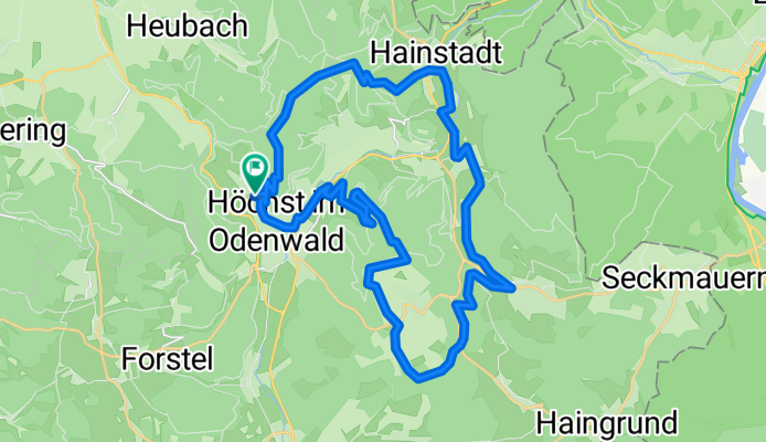
- über die Hohe Straße
- Distance
- 25.3 km
- Ascent
- 377 m
- Descent
- 373 m
- Location
- Höchst im Odenwald, Hesse, Germany
- zum Biergarten nach Umscht
- Distance
- 30.8 km
- Ascent
- 470 m
- Descent
- 465 m
- Location
- Höchst im Odenwald, Hesse, Germany
Open it in the app