Otzberg und so...
A cycling route starting in Höchst im Odenwald, Hesse, Germany.
Overview
About this route
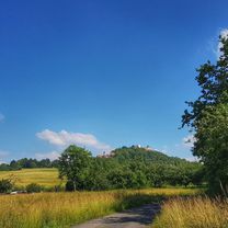
In the afternoon, I finally took another ride. A gloomy lighting today, but not so warm. Good like this. #noebike
- -:--
- Duration
- 26.6 km
- Distance
- 564 m
- Ascent
- 566 m
- Descent
- ---
- Avg. speed
- ---
- Max. altitude
Route photos
Continue with Bikemap
Use, edit, or download this cycling route
You would like to ride Otzberg und so... or customize it for your own trip? Here is what you can do with this Bikemap route:
Free features
- Save this route as favorite or in collections
- Copy & plan your own version of this route
- Sync your route with Garmin or Wahoo
Premium features
Free trial for 3 days, or one-time payment. More about Bikemap Premium.
- Navigate this route on iOS & Android
- Export a GPX / KML file of this route
- Create your custom printout (try it for free)
- Download this route for offline navigation
Discover more Premium features.
Get Bikemap PremiumFrom our community
Other popular routes starting in Höchst im Odenwald
- zum Biergarten nach Umscht
- Distance
- 30.8 km
- Ascent
- 470 m
- Descent
- 465 m
- Location
- Höchst im Odenwald, Hesse, Germany
- Frankfurter Straße-Binselberg-Wendelinuskapelle-Umstadt
- Distance
- 35.7 km
- Ascent
- 479 m
- Descent
- 477 m
- Location
- Höchst im Odenwald, Hesse, Germany
- 3 Brunnen Runde
- Distance
- 31.2 km
- Ascent
- 441 m
- Descent
- 437 m
- Location
- Höchst im Odenwald, Hesse, Germany
- Waldhaus Obernburg
- Distance
- 35.4 km
- Ascent
- 334 m
- Descent
- 332 m
- Location
- Höchst im Odenwald, Hesse, Germany
- Rimhorn-Lützelbach-Hainstadt Runde
- Distance
- 30.4 km
- Ascent
- 617 m
- Descent
- 620 m
- Location
- Höchst im Odenwald, Hesse, Germany
- durch den Mühlgrund
- Distance
- 42.9 km
- Ascent
- 411 m
- Descent
- 408 m
- Location
- Höchst im Odenwald, Hesse, Germany
- Toter Mann - Kimbach - Bad König
- Distance
- 35.6 km
- Ascent
- 608 m
- Descent
- 607 m
- Location
- Höchst im Odenwald, Hesse, Germany
- Zur Konfirmanden Buche und in den Kellergrund
- Distance
- 25.4 km
- Ascent
- 789 m
- Descent
- 785 m
- Location
- Höchst im Odenwald, Hesse, Germany
Open it in the app